
Image: Manteno civilisation map

Size of this preview: 560 × 599 pixels. Other resolutions: 224 × 240 pixels | 598 × 640 pixels.
Original image (598 × 640 pixels, file size: 31 KB, MIME type: image/jpeg)
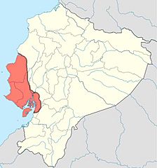
Description: Map of the en:Manteño civilisation in Ecuador. Overlaid on the original map using the text source Peregrine, P. N., et al. (2001) Encyclopedia of Prehistory: Middle America, 5, p. 307 Retrieved on 28 March 2010. . In particular, the eastern boundary is uncertain, with most settlement on the coast.
Title: Manteno civilisation map
Credit: Ecuador_location_map.svg
Author: Ecuador_location_map.svg: NordNordWest derivative work: Jarry1250 (talk)
Usage Terms: GNU Free Documentation License 1.2
License: GFDL 1.2
License Link: http://www.gnu.org/licenses/old-licenses/fdl-1.2.html
Attribution Required?: Yes
Image usage
The following page links to this image:

All content from Kiddle encyclopedia articles (including the article images and facts) can be freely used under Attribution-ShareAlike license, unless stated otherwise.