
Image: Map Japan Genki1-en

Size of this PNG preview of this SVG file: 443 × 266 pixels. Other resolution: 320 × 192 pixels.
Original image (SVG file, nominally 443 × 266 pixels, file size: 291 KB)
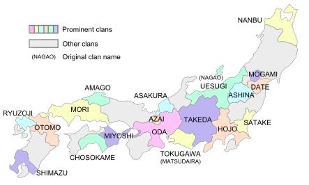
Description: Map of the territories of the Sengoku daimyo around the first year of the Genki era (1570 AD). English version of file:Map Japan Genki1.png.
Title: Map Japan Genki1-en
Credit: Own work
Author: Ro4444
Usage Terms: Creative Commons Attribution-Share Alike 4.0
License: CC BY-SA 4.0
License Link: https://creativecommons.org/licenses/by-sa/4.0
Attribution Required?: Yes
Image usage
The following page links to this image:

All content from Kiddle encyclopedia articles (including the article images and facts) can be freely used under Attribution-ShareAlike license, unless stated otherwise.