
Image: Map Kingdom of Brittany 845-867-fr

Size of this PNG preview of this SVG file: 700 × 600 pixels. Other resolution: 280 × 240 pixels.
Original image (SVG file, nominally 700 × 600 pixels, file size: 39 KB)
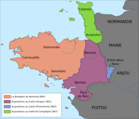
Description: Approximate borders of the Brittany kingdom (845-867).
Title: Map Kingdom of Brittany 845-867-fr
Credit: France - Grand Ouest - map-blank.svg Louis Élegoët, Bretagne une histoire, CRDP de Bretagne, 2000, p. 54 : Limites successives de la Bretagne au IXe siècle. Il était une fois l'Ouest, éditions Ouest-France, 2009, p.11 : Les frontières de la Bretagne des origines au XVe siècle.
Author: France - Grand Ouest - map-blank.svg: (Sémhur derivative work: Fab5669 (talk)
Usage Terms: Creative Commons Attribution-Share Alike 3.0
License: CC BY-SA 3.0
License Link: https://creativecommons.org/licenses/by-sa/3.0
Attribution Required?: Yes
Image usage
The following page links to this image:

All content from Kiddle encyclopedia articles (including the article images and facts) can be freely used under Attribution-ShareAlike license, unless stated otherwise.