
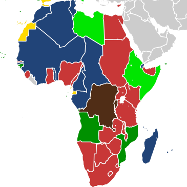
Image: Map of Africa in 1939

Size of this PNG preview of this SVG file: 365 × 365 pixels. Other resolution: 240 × 240 pixels.
Original image (SVG file, nominally 365 × 365 pixels, file size: 1.53 MB)
Description: Map showing the European colonial empires in Africa in 1939. Belgian colonial empire British colonial empire French colonial empire Italian colonial empire Portuguese colonial empire Spanish colonial empire
Title: Map of Africa in 1939
Credit: Own work (based upon: File:Map of Africa in 1939.png + File:1937 world map (Winkel tripel projection).svg)
Author: Cukrakalnis
Usage Terms: Creative Commons Attribution-Share Alike 4.0
License: CC BY-SA 4.0
License Link: https://creativecommons.org/licenses/by-sa/4.0
Attribution Required?: Yes
Image usage
The following page links to this image:

All content from Kiddle encyclopedia articles (including the article images and facts) can be freely used under Attribution-ShareAlike license, unless stated otherwise.