
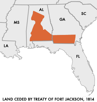
Image: Map of Land Ceded by Treaty of Fort Jackson
No higher resolution available.
Map_of_Land_Ceded_by_Treaty_of_Fort_Jackson.png (320 × 336 pixels, file size: 11 KB, MIME type: image/png)
Description: Map of Land Ceded to the United States by the warring Creek Nations in the Treaty of Fort Jackson of 1814. User:Dystopos created this map using as reference a map "Creek Land Cessions Map 1733 through 1832" from the Horseshoe Bend National Military Park page on Areaparks.com [1]
Title: Map of Land Ceded by Treaty of Fort Jackson
Credit: http://en.wikipedia.org/wiki/Image:Map_of_Land_Ceded_by_Treaty_of_Fort_Jackson.png
Author: User:Dystopos
Permission: No Rights Reserved
Usage Terms: Public domain
License: Public domain
Attribution Required?: No
Image usage
The following 4 pages link to this image:

All content from Kiddle encyclopedia articles (including the article images and facts) can be freely used under Attribution-ShareAlike license, unless stated otherwise.