
Image: Map of Ur III

Size of this PNG preview of this SVG file: 350 × 400 pixels. Other resolution: 210 × 240 pixels.
Original image (SVG file, nominally 350 × 400 pixels, file size: 335 KB)
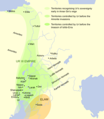
Description: This map shows the extents of the Ur III Empire in Mesopotamia circa the 22nd century BCE. Map oriented towards approximately northwest for some reason. based on Garelli, Paul: «El Imperio de Ur y su herencia», en El Próximo Oriente asiático. Barcelona: Labor 1974. ISBN 8433593102. Map from File:Ciudades del antiguo Oriente Medio.svg.
Title: Map of Ur III
Credit: Mapa_Tercera_Dinastia_de_Ur.svg
Author: Mapa_Tercera_Dinastia_de_Ur.svg: Crates derivative work: Chaim The Bipolar (talk)
Usage Terms: Creative Commons Attribution-Share Alike 3.0
License: CC BY-SA 3.0
License Link: https://creativecommons.org/licenses/by-sa/3.0
Attribution Required?: Yes
Image usage
The following 2 pages link to this image:

All content from Kiddle encyclopedia articles (including the article images and facts) can be freely used under Attribution-ShareAlike license, unless stated otherwise.