
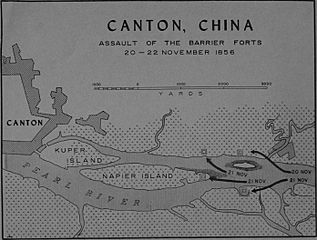
Image: Map of the Barrier Forts

Size of this preview: 791 × 600 pixels. Other resolutions: 317 × 240 pixels | 2,784 × 2,111 pixels.
Original image (2,784 × 2,111 pixels, file size: 620 KB, MIME type: image/jpeg)
Description: Map of the assault on the Barrier Forts, 20–22 November 1856.
Title: Map of the Barrier Forts
Credit: Bernard C. Nalty (1962). The Barrier Forts: A Battle, a Monument, and a Mythical Marine. Washington D.C.: Historical Branch, G-3 Division, Headquarters, U.S. Marine Corps.
Author: Nalty
Usage Terms: Public domain
License: Public domain
Attribution Required?: No
Image usage
The following page links to this image:

All content from Kiddle encyclopedia articles (including the article images and facts) can be freely used under Attribution-ShareAlike license, unless stated otherwise.