
Image: Map of the Dismal Swamp Canal 1867

Size of this preview: 477 × 599 pixels. Other resolutions: 191 × 240 pixels | 3,910 × 4,911 pixels.
Original image (3,910 × 4,911 pixels, file size: 2.48 MB, MIME type: image/jpeg)
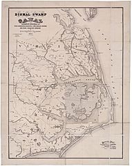
Description: "Map of the Dismal Swamp Canal," by D. S. Walton. Civil Engineer, 1867. Courtesy of the University of North Carolina Libraries.
Title: Map of the Dismal Swamp Canal 1867
Credit: http://www.learnnc.org/lp/multimedia/9393
Author: map by D. S. Walton (published by Hosford & Sons)
Usage Terms: Public domain
License: Public domain
Attribution Required?: No
Image usage
The following page links to this image:

All content from Kiddle encyclopedia articles (including the article images and facts) can be freely used under Attribution-ShareAlike license, unless stated otherwise.