
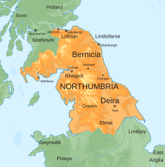
Image: Map of the Kingdom of Northumbria around 700 AD

Size of this PNG preview of this SVG file: 586 × 594 pixels. Other resolution: 237 × 240 pixels.
Original image (SVG file, nominally 586 × 594 pixels, file size: 800 KB)
Description: Map of the Anglo-Saxon Kingdom of Northumbria around 700 AD
Title: Map of the Kingdom of Northumbria around 700 AD
Credit: Blank topographic map of the British Isles.svg Derivative work: Own work
Author: Hogweard
Usage Terms: Creative Commons Attribution-Share Alike 4.0
License: CC BY-SA 4.0
License Link: https://creativecommons.org/licenses/by-sa/4.0
Attribution Required?: Yes
Image usage
The following 2 pages link to this image:

All content from Kiddle encyclopedia articles (including the article images and facts) can be freely used under Attribution-ShareAlike license, unless stated otherwise.