
Image: Map of the Street Railways of the State of Massachusetts, 1913

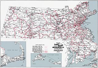
Description: Map of the interurban systems as they existed, or were otherwise proposed, in Massachusetts prior to World War I. Note the density of street railways around urban centers like Boston, Worcester, Springfield, and Pittsfield, in contrast to the lack of railways in the present location of the Quabbin Reservoir and Cape Cod.
Title: Map of the Street Railways of the State of Massachusetts, 1913
Credit: Report of the Joint Special Committee on the Transportation Facilities of Western Massachusetts
Author: Walter Lithography
Permission: Public domainPublic domainfalsefalse This work is based on a work in the public domain. It has been digitally enhanced and/or modified. This derivative work has been (or is hereby) released into the public domain by its author, Simtropolitan. This applies worldwide. In some countries this may not be legally possible; if so: Simtropolitan grants anyone the right to use this work for any purpose, without any conditions, unless such conditions are required by law. العربية ∙ беларуская (тарашкевіца) ∙ English ∙ español ∙ français ∙ हिन्दी ∙ italiano ∙ 日本語 ∙ ಕನ್ನಡ ∙ македонски ∙ മലയാളം ∙ русский ∙ sicilianu ∙ українська ∙ 简体中文 ∙ 繁體中文 ∙ +/−
Usage Terms: Public domain
License: Public domain
Attribution Required?: No
Image usage
The following page links to this image:
