
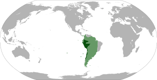
Image: Map of the Viceroyalty of Peru

Size of this PNG preview of this SVG file: 800 × 407 pixels. Other resolution: 320 × 163 pixels.
Original image (SVG file, nominally 3,121 × 1,586 pixels, file size: 1.67 MB)
Description: Locator map of the Viceroyalty of Peru (initial (1542) and final (1810) de jure territory).
Title: Map of the Viceroyalty of Peru
Credit: Own work File:BlankMap-World-90W.svg File:Location_ViceroyaltyPeru.png Virreinato del Perú en 1810 File:Audencias of Viceroyalty of Peru.PNG
Author: Shadowxfox
Usage Terms: Creative Commons Attribution-Share Alike 3.0
License: CC BY-SA 3.0
License Link: http://creativecommons.org/licenses/by-sa/3.0
Attribution Required?: Yes
Image usage
The following 2 pages link to this image:

All content from Kiddle encyclopedia articles (including the article images and facts) can be freely used under Attribution-ShareAlike license, unless stated otherwise.