
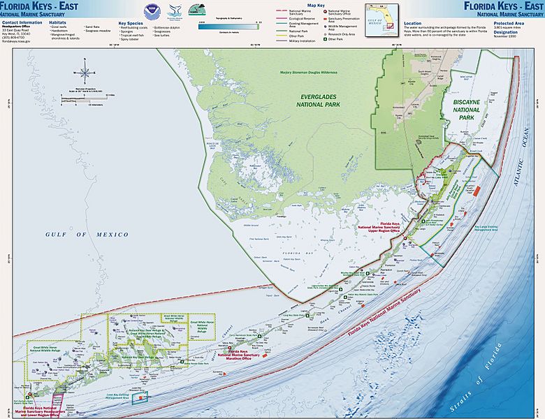
Image: Map of the eastern Florida Keys, from Key West to the Ragged Keys in Biscayne National Park, showing boundaries of National Marine Sanctuaries 2000

Size of this preview: 780 × 600 pixels. Other resolutions: 312 × 240 pixels | 1,950 × 1,499 pixels.
Original image (1,950 × 1,499 pixels, file size: 687 KB, MIME type: image/jpeg)
Description: Map of the Florida Keys, showing National Marine Sanctuaries
Title: Map of the eastern Florida Keys, from Key West to the Ragged Keys in Biscayne National Park, showing boundaries of National Marine Sanctuaries 2000
Credit: http://sanctuaries.noaa.gov/pgallery/atlasmaps/fkeast.html
Author: Sanctuaries Web Team of National Ocean Service of National Oceanic and Atmospheric Administration of U.S. Department of Commerce
Permission: U.S. Federal Government work, therefore public domain
Usage Terms: Public domain
License: Public domain
Attribution Required?: No
Image usage
The following image is a duplicate of this image (more details):
There are no pages that link to this image.

All content from Kiddle encyclopedia articles (including the article images and facts) can be freely used under Attribution-ShareAlike license, unless stated otherwise.