
Image: Map of traditional provinces of Libye-en

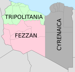
Description: Map of the three Governorates of Libya based on the borders of today's governorates. After independence in 1951, until 1963, Libya was divided into three governorates (muhafazat): Cyrenaica, Tripolitania, and Fezzan. The eastern border between Tripolitania and Fezzan was before 1969 slightly different: the northern part of Al Jufrah District in today's Fezzan belonged to Tripolitania, see here File:Ottoman Provinces Of Present day Libyapng.png.
Title: Map of traditional provinces of Libye-en
Credit: Map_of_traditionnal_provinces_of_Libye_fr.svg
Author: Map_of_traditionnal_provinces_of_Libye_fr.svg: *Libya_location_map.svg: NordNordWest derivative work: Xfigpower (pssst) derivative work: Bourrichon (talk)
Usage Terms: Creative Commons Attribution 3.0
License: CC BY 3.0
License Link: https://creativecommons.org/licenses/by/3.0
Attribution Required?: Yes
Image usage
The following 3 pages link to this image:
