
Image: Mapa de Comunidades Indígenas Argentina.pdf
Size of this JPG preview of this PDF file: 424 × 599 pixels. Other resolution: 170 × 240 pixels.
Original image (1,240 × 1,753 pixels, file size: 1.13 MB, MIME type: application/pdf)
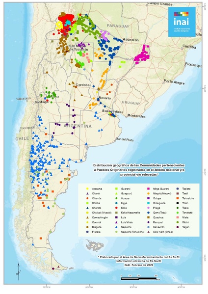
Description: Es un mapa de todo el país en el que podrás observar la localización aproximada de las Comunidades Indígenas con Personería Jurídica inscripta tanto a nivel nacional como provincial y/o han sido relevadas en el marco de Programa Nacional Relevamiento Territorial de Comunidades Indígenas (Re.Te.C.I. - Ejecución de la Ley Nº 26.160 y sus prórrogas)
Author: Instituto Nacional de Asuntos Indígenas
Usage Terms: Creative Commons Attribution-Share Alike 3.0
License: CC-BY-SA-3.0
License Link: http://creativecommons.org/licenses/by-sa/3.0/
Attribution Required?: Yes
Image usage
The following page links to this image:

All content from Kiddle encyclopedia articles (including the article images and facts) can be freely used under Attribution-ShareAlike license, unless stated otherwise.