
Image: Mars Curiosity Rover - Yellowknife Landing Site

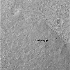
Description: 08.10.2012 Curiosity's Quad This image shows the quadrangle where NASA's Curiosity rover landed, now called Yellowknife. The mission's science team has divided the landing region into several square quadrangles, or quads, of interest about 1-mile (1.3-kilometers) wide. This will allow groups of team members to focus their analysis on a particular part of the surface. Yellowknife is a city in northwestern Canada and a group of rocks from the same region. The rocks were formed 2.7 billion years ago from both volcanoes and sediments laid down by water, and were deposited over 4-billion-year-old rocks, the oldest known on Earth. The image was obtained by the High-Resolution Imaging Science Experiment (HiRISE) camera on NASA's Mars Reconnaissance Orbiter. HiRISE is one of six instruments on NASA's Mars Reconnaissance Orbiter. The University of Arizona, Tucson, operates the orbiter's HiRISE camera, which was built by Ball Aerospace & Technologies Corp., Boulder, Colo. NASA's Jet Propulsion Laboratory, a division of the California Institute of Technology in Pasadena, manages the Mars Reconnaissance Orbiter Project for the NASA Science Mission Directorate, Washington. Lockheed Martin Space Systems, Denver, built the spacecraft. Image Credit: NASA/JPL-Caltech/Univ. of Arizona
Title: Mars Curiosity Rover - Yellowknife Landing Site
Credit: http://mars.jpl.nasa.gov/msl/multimedia/images/?ImageID=4408
Author: NASA/JPL-Caltech/Univ. of Arizona
Usage Terms: Public domain
License: Public domain
Attribution Required?: No
Image usage
There are no pages that link to this image.
