
Image: Minneapolis–St. Paul–St. Cloud CSA
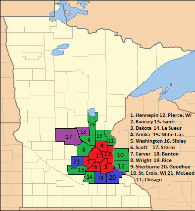
Description: This a map of the 21 counties of the Minneapolis-St. Paul-St. Cloud Combined Statical Area as of 2013. The map is divided into 4 colors: Red=Urbanized counties that are under jurisdiction of the Metropolitan Council Green=Other counties included the Minneapolis-St. Paul-Bloomington Metropolitan Statistical Area Purple=Counties included in the St. Cloud Metropolitan Statistical Area Blue=Counties that are separate Micropolitan Statistical Areas Directory of counties: 1. Hennepin 12. Pierce, WI 2. Ramsey 13. Isanti 3. Dakota 14. Le Sueur 4. Anoka 15. Mille Lacs 5. Washington 16. Sibley 6. Scott 17. Sterns 7. Carver 18. Benton 8. Wright 19. Rice 9. Sherburne 20. Goodhue 10. St. Croix, WI 21. McLeod 11. Chisago
Title: Minneapolis–St. Paul–St. Cloud CSA
Credit: https://commons.wikimedia.org/wiki/File:Minnesota_Locator_Map.PNG, US Census Website
Author: US Census, Ruhrfisch
Usage Terms: Creative Commons Attribution-Share Alike 3.0
License: CC BY-SA 3.0
License Link: http://creativecommons.org/licenses/by-sa/3.0
Attribution Required?: Yes
Image usage
The following page links to this image:
