
Image: NB 1866-1871.99

Size of this PNG preview of this SVG file: 648 × 600 pixels. Other resolution: 259 × 240 pixels.
Original image (SVG file, nominally 971 × 899 pixels, file size: 1.88 MB)
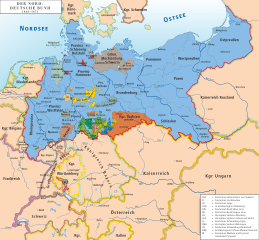
Description: Map of North German Confederation 1866–1871
Title: NB 1866-1871.99
Credit: own drawing/Source of Information: Putzger – Historischer Weltatlas, 89. Auflage, 1965; Westermanns Großer Atlas zur Weltgeschichte, 1969; Haacks geographischer Atlas. VEB Hermann Haack Geographisch-Kartographische Anstalt, Gotha/Leipzig, 1. Auflage, 1979; dtv-Atlas zur Weltgeschichte Band 1: Von den Anfängen bis zur Französischen Revolution; 23. Aufl. 1989, ISBN 3-423-03002-X
Author: Ziegelbrenner
Permission: You may select the license of your choice.
Usage Terms: Creative Commons Attribution 2.5
License: CC BY 2.5
License Link: https://creativecommons.org/licenses/by/2.5
Attribution Required?: Yes
Image usage
The following page links to this image:

All content from Kiddle encyclopedia articles (including the article images and facts) can be freely used under Attribution-ShareAlike license, unless stated otherwise.