
Image: NRHP Massachusetts Map

Size of this PNG preview of this SVG file: 776 × 600 pixels. Other resolution: 311 × 240 pixels.
Original image (SVG file, nominally 792 × 612 pixels, file size: 584 KB)
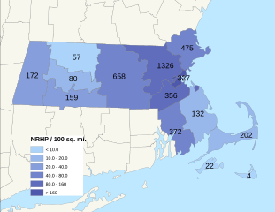
Description: Map of Massachusetts National Register of Historic Places listings density by county, measured in listings per 100 sq. mi. Data is current as of 09/06/2012.
Title: NRHP Massachusetts Map
Credit: Own work
Author: 25or6to4, User:Magicpiano
Usage Terms: Creative Commons Attribution-Share Alike 3.0
License: CC BY-SA 3.0
License Link: http://creativecommons.org/licenses/by-sa/3.0
Attribution Required?: Yes
Image usage
The following page links to this image:

All content from Kiddle encyclopedia articles (including the article images and facts) can be freely used under Attribution-ShareAlike license, unless stated otherwise.