
Image: NZOMC

Size of this preview: 434 × 599 pixels. Other resolutions: 174 × 240 pixels | 941 × 1,298 pixels.
Original image (941 × 1,298 pixels, file size: 87 KB, MIME type: image/png)
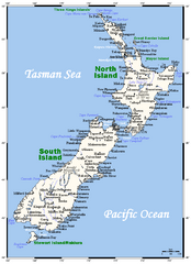
Description: A map showing New Zealand's cities, main towns, selected villages, rivers and its highest peaks. This map's source is here, with the uploader's modifications, and the GMT homepage says that the tools are released under the GNU General Public License.
Title: NZOMC
Credit: Transferred from en.wikipedia to Commons by Rehman using CommonsHelper.
Author: Kelisi at English Wikipedia
Usage Terms: Creative Commons Attribution-Share Alike 3.0
License: CC-BY-SA-3.0
License Link: http://creativecommons.org/licenses/by-sa/3.0/
Attribution Required?: Yes
Image usage
There are no pages that link to this image.

All content from Kiddle encyclopedia articles (including the article images and facts) can be freely used under Attribution-ShareAlike license, unless stated otherwise.