
Image: Nez Perce route Big Hole to Camas Meadows

Size of this preview: 505 × 599 pixels. Other resolutions: 202 × 240 pixels | 702 × 833 pixels.
Original image (702 × 833 pixels, file size: 369 KB, MIME type: image/png)
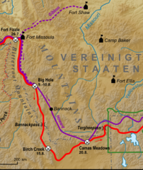
Description: A cropped version of a map already published on Wikimedia which shows the Nez Perce and General Howard's routes from the Battle of the Big Hole to the Battle of Camas Creek
Title: Nez Perce route Big Hole to Camas Meadows
Credit: File:Feldzug gegen die Nez Perce 1877.png by Lencer
Author: Smallchief
Usage Terms: GNU Free Documentation License
License: GFDL
License Link: http://www.gnu.org/copyleft/fdl.html
Attribution Required?: Yes
Image usage
The following page links to this image:

All content from Kiddle encyclopedia articles (including the article images and facts) can be freely used under Attribution-ShareAlike license, unless stated otherwise.