
Image: Nork 1945 OSmap
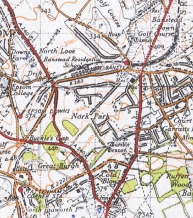
Description: Detail from Ordnance Survey "New Popular Edition" (1945) map at scale of 1:63360. The area shown covers the Nork ward as defined in 2015. About half of the Nork estates that were to be built by the end of the 20th century have been completed by this date, but, for instance, Nork Way does not continue to the Reigate Road. This work is based on data provided through www.VisionofBritain.org.uk and uses historical material which is copyright of the Great Britain Historical GIS Project and the University of Portsmouth.
Title: Nork 1945 OSmap
Credit: www.VisionofBritain.org.uk; The British Library, www.bl.uk; cropped version by J.M.C. Hutchinson
Author: Ordnance Survey, J.M.C. Hutchinson
Permission: This file is licensed under the Creative Commons Attribution-Share Alike 4.0 International license. You are free: to share – to copy, distribute and transmit the work to remix – to adapt the work Under the following conditions: attribution – You must attribute the work in the manner specified by the author or licensor (but not in any way that suggests that they endorse you or your use of the work). share alike – If you alter, transform, or build upon this work, you may distribute the resulting work only under the same or similar license to this one. http://creativecommons.org/licenses/by-sa/4.0 CC BY-SA 4.0 Creative Commons Attribution-Share Alike 4.0 truetrue
Usage Terms: Creative Commons Attribution-Share Alike 4.0
License: CC BY-SA 4.0
License Link: http://creativecommons.org/licenses/by-sa/4.0
Attribution Required?: Yes
Image usage
The following page links to this image:
