
Image: Nunavik map

Size of this PNG preview of this SVG file: 516 × 599 pixels. Other resolution: 207 × 240 pixels.
Original image (SVG file, nominally 1,184 × 1,375 pixels, file size: 1.09 MB)
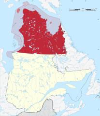
Description: Nunavik as definied by the Makivik Corporation, highlighted on the map of Quebec, Canada. Territory within the Province of Quebec is coloured dark red, offshore islands that are part of Nunavut are in lighter red. Islands claimed as joint Nunavut-Nunavik territory are hatched.
Title: Nunavik map
Credit: Own work, base map from File:Canada Quebec location map-conic proj2.svg, borders from [1] and [2]
Author: Fenn-O-maniC
Usage Terms: Creative Commons Attribution-Share Alike 4.0
License: CC BY-SA 4.0
License Link: https://creativecommons.org/licenses/by-sa/4.0
Attribution Required?: Yes
Image usage
The following page links to this image:

All content from Kiddle encyclopedia articles (including the article images and facts) can be freely used under Attribution-ShareAlike license, unless stated otherwise.