
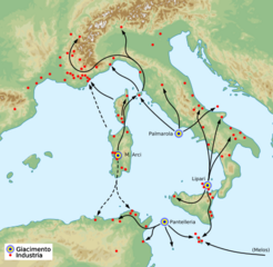
Image: Obsidian diffusion Mediterranean map

Size of this PNG preview of this SVG file: 452 × 441 pixels. Other resolution: 246 × 240 pixels.
Original image (SVG file, nominally 452 × 441 pixels, file size: 2.27 MB)
Description: Obsidian diffusion mediterranean map
Title: Obsidian diffusion Mediterranean map
Credit: This file was derived from: Western Europe DEMIS topographic map.svg: Based on "Gabriel Camps, La navigation en France au Néolithique et à l’Age du Bronze, in 'La Préhistoire Francaise', 2: 193-201 (1976)"
Author: Western_Europe_DEMIS_topographic_map.svg: Pethrus derivative work: Fulvio314
Usage Terms: Creative Commons Attribution-Share Alike 3.0
License: CC BY-SA 3.0
License Link: https://creativecommons.org/licenses/by-sa/3.0
Attribution Required?: Yes
Image usage
The following page links to this image:

All content from Kiddle encyclopedia articles (including the article images and facts) can be freely used under Attribution-ShareAlike license, unless stated otherwise.