
Image: Ohlone color map bands

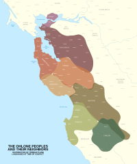
Description: Color map of Ohlone territory with bands indicated This file was derived from: Ohlone color map with locator-01.svg Sources: Randall Milliken (1995): https://museumsrv.org/the-bay-miwok-language-and-land/ California Indians and Their Environment: An Introduction (pg 34) Randall Milliken (2007) https://www.researchgate.net/publication/256521471_Punctuated_Culture_Change_in_the_San_Francisco_Bay_Area Randall Milliken (2009): http://npshistory.com/publications/goga/coast-miwok-ethnohistory.pdf Randall Milliken (2010): Treasures from Native California: The Legacy of Russian Exploration (pg 2) Isabel Truesdell Kelly (1991) https://northbaydigital.sonoma.edu/digital/collection/EHDC/id/1357/ Unknown source: https://www.ebparks.org/civicax/filebank/blobdload.aspx?blobid=30644 (pgs 9, 10) William J Wallace https://www.yumpu.com/en/document/view/18109468/northern-valley-yokuts-state-of-california (462/1) James A. Bennyhoff (1977) https://www.standupca.org/off-reservation-gaming/contraversial-applications-in-process/wilton-miwok-rancheria/jan-2016-beckham-report-wilton-rancheria
Title: Ohlone color map bands
Credit: Own work
Author: Noahedits
Usage Terms: Creative Commons Attribution-Share Alike 4.0
License: CC BY-SA 4.0
License Link: https://creativecommons.org/licenses/by-sa/4.0
Attribution Required?: Yes
Image usage
The following page links to this image:
