
Image: Oil Deliveries From Hormuz
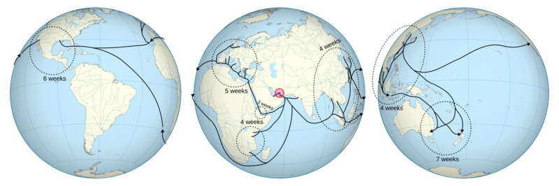
Description: Orthographic maps of the world, centred on the Strait of Hormuz, annotated with oil delivery shipping lines and approximate delivery time. The central image is centred on the Strait of Hormuz, the left image shows 120° to the west (showing the Americas), and the right image shows 120° to the east (showing the Pacific). This image was created with a basic annotation layer with the hope that other people will be able to improve it. Feel free to update the Annotations layer with additional annotations and / or corrections. Base orthographic images were created from Natural Earth Data shapefiles using David Eccles' (gringer) perlshaper.pl script, version 2.11, using the following options:
Hormuz: -color location -type orthographic -res 0.1 -centre 56.5,26.6 ne_50m_land.shp ne_50m_rivers_lake_centerlines.shp ne_50m_lakes.shp Pacific: -color location -type orthographic -res 0.1 -centre 176.5,-8.87 ne_50m_land.shp ne_50m_rivers_lake_centerlines.shp ne_50m_lakes.shp America: -color location -type orthographic -res 0.1 -centre 296.5,-8.87 ne_50m_land.shp ne_50m_rivers_lake_centerlines.shp ne_50m_lakes.shp
Data for the shipping paths and approximate delivery times is based on the JP Morgan Commodities Research / Kpler image "Figure 1: Oil Flows from the Persian Gulf and South East Asia".
Paths and text annotations were added using Inkscape v1.4.2, and the SVG source was then cleaned up using Emacs and Perl.
Author: Gringer
Usage Terms: Creative Commons Attribution-Share Alike 3.0
License: CC-BY-SA-3.0
License Link: http://creativecommons.org/licenses/by-sa/3.0/
Attribution Required?: Yes
Image usage
The following page links to this image:
