
Image: Ottoman Empire 1914 fr

Size of this preview: 517 × 600 pixels. Other resolutions: 207 × 240 pixels | 530 × 615 pixels.
Original image (530 × 615 pixels, file size: 51 KB, MIME type: image/png)
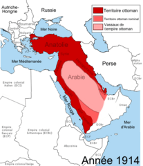
Description: Map showing the territories of the Ottoman Empire in 1914, including nominal and vassal territories. According to the information on the map in http://ottomanmilitary.devhub.com/
Title: Ottoman Empire 1914 fr
Credit:
Author: User:DragonTiger23
Usage Terms: Creative Commons Zero, Public Domain Dedication
License: CC0
License Link: http://creativecommons.org/publicdomain/zero/1.0/deed.en
Attribution Required?: No
Image usage
The following page links to this image:

All content from Kiddle encyclopedia articles (including the article images and facts) can be freely used under Attribution-ShareAlike license, unless stated otherwise.