
Image: Overmountain-men-march-map1
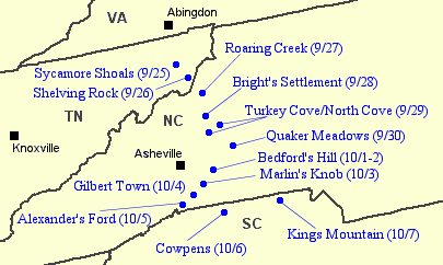
Description: Map showing the general march route of the Overmountain Men— the frontier militia that helped defeat the British loyalists at Kings Mountain in 1780. The main body mustered at Sycamore Shoals, in modern Elizabethton, Tennessee, on September 25, 1780, and departed the following morning. "Shelving Rock" is just south of the town of Roan Mountain, Tennessee. The force camped at the confluence of Bright's Branch and Roaring Creek on September 27, and at Bright's settlement (modern Spruce Pines, N.C.) on September 28. Quaker Meadows is located in modern Morganton, North Carolina. Gilbert Town is near modern Rutherfordton, North Carolina. Cowpens is north of Spartanburg, South Carolina. Abingdon and the modern cities of Knoxville and Asheville are shown for reference.
Title: Overmountain-men-march-map1
Credit: Own work
Author: Brian Stansberry
Usage Terms: Public domain
License: Public domain
Attribution Required?: No
Image usage
The following page links to this image:
