
Image: PNR Rail Map

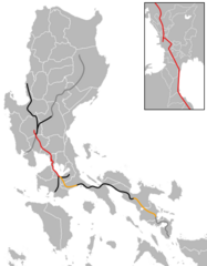
Description: A map of the Philippine National Railways network, which includes active lines (orange), inactive lines (black), historically proposed lines (gray) and the under-construction North-South Commuter Railway (red). This is an SVG reproduction and update of File:PNR_North_and_South_map.png. Based on the following maps and templates: File:Philippine National Railways.png File:PNR South Long Haul Map.png File:PNR Luzon Railways Program.png en:File:Philippine railways during its peak.jpg File:Philippine National Railways Route Map.jpg File:Blank_map_of_the_Philippines_(Provinces_and_indepedent_cities).svg File:Blank_map_of_the_Philippines_(Provinces).svg
Title: PNR Rail Map
Credit: Own work
Author: ByteMega
Usage Terms: Creative Commons Attribution-Share Alike 4.0
License: CC BY-SA 4.0
License Link: https://creativecommons.org/licenses/by-sa/4.0
Attribution Required?: Yes
Image usage
The following page links to this image:
