
Image: Patroon Island - Before & After

Size of this preview: 800 × 476 pixels. Other resolutions: 320 × 190 pixels | 841 × 500 pixels.
Original image (841 × 500 pixels, file size: 220 KB, MIME type: image/jpeg)
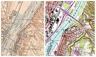
Description: Source: Maps taken from the public domain USGS Digital Raster Graphic files, map on left is from 1927, map on right is from current Albany quadrangles. Map on the Left shows the former Lower Patroon Island, an Island in the Hudson River, just north of Albany, New York. Map on the right shows that the highway interchange of I-787 (North-South) and I-90 (East-West), with the Patroon Island Bridge partially on the grounds of the former Lower Patroon Island.
Title: Patroon Island - Before & After
Usage Terms: Public domain
License: Public domain
Attribution Required?: No
Image usage
The following page links to this image:

All content from Kiddle encyclopedia articles (including the article images and facts) can be freely used under Attribution-ShareAlike license, unless stated otherwise.