
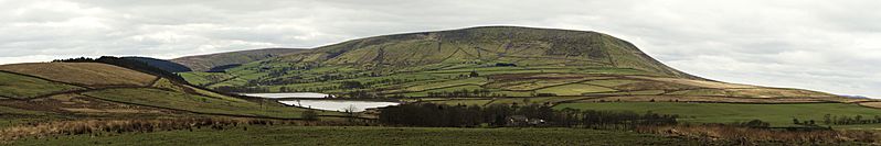
Image: Pendle Hill panorama (nagualdesign)

Description: A panoramic image of Pendle Hill, Lancashire, showing the northeast slopes, known as the Big End, photographed from Wheathead Lane on the edge of Barley-with-Wheatley Booth. To the left are Aitken Wood and Black Moss Reservoirs. The footpath from Barley (not pictured) to the summit can be seen ascending from left to right. To the far right of the image, visible in the distance 8.25 miles away, is the radio mast on Waddington Fell.
Title: Pendle Hill panorama (nagualdesign)
Credit: Own work
Author: Joe Haythornthwaite (nagualdesign)
Permission: This image is protected by copyright law. However, it may be used for free by anyone, provided that it's used in accordance with the Creative Commons Attribution-ShareAlike 4.0 International license using the attribution "nagualdesign (CC BY-SA 4.0)". Please read the license carefully before using this image. If you have any questions regarding the license or the reuse of the image please contact me before using it.
Usage Terms: Creative Commons Attribution-Share Alike 4.0
License: CC BY-SA 4.0
License Link: https://creativecommons.org/licenses/by-sa/4.0
Attribution Required?: Yes
Image usage
The following page links to this image:

.jpg)