
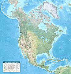
Image: Physical Features of North America map by Tom Patterson v. 1.01, meters

Description: Description on website: "North America is an ideal continent for physical mapping. The irregular coast, varied terrain, and diverse environments form a cartographic mosaic of colors and textures. Besides being beautiful, these features also tell geographic stories. The cordillera running along the entire Pacific coast gives evidence of the theory of plate tectonics. And looking south from Canada’s arctic islands to Panama’s rain forests, we see the influence of latitude and elevation on natural vegetation. I made this map during the winter of 2020-21 to keep busy during the pandemic. It is comprised of freely available geospatial data that I manipulated using GIS and graphical software. To decide which features to label, I consulted maps, atlases, and numerous online sites, including Peakbagger, PeakVisor, and Wikipedia. I am very grateful to the many people on Twitter who commented on a draft of the map. I hope that you enjoy using the map as much as I did making it." Description on map: "Starting with the lowest area, Blue Earth Bathymetry depicts the ocean floor. Land colors are a mix of Natural Earth 2 and Copernicus Land Cover. I muted land cover contrast in humid regions to better depict subtle terrain features. Shaded relief derives from generalized STM elevation data. Coastlines, lakes, and rivers are from Natural Earth, with additions. Atlases and a multitude of online sources, including Peakbagger, PeakVisor, and Wikipedia, are the source of feature names and elevations. I am very grateful to the dozens of people who reviewed the map and offered helpful suggestions. Cartography by Tom Patterson, v. 1.01, March 9, 2021. Map available at: www.shadedrelief.com/north-america Elevations and ocean depths are in meters. Lambert Azimuthal Equal-Area Projection Central meridian 95° W Latitude of origin 45° N"
Title: Physical Features of North America map by Tom Patterson v. 1.01, meters
Credit: http://www.shadedrelief.com/north-america
Author: Tom Patterson
Usage Terms: Public domain
License: Public domain
Attribution Required?: No
Image usage
The following page links to this image:
