
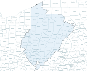
Image: Pittsburgh Megaregion Boundaries (Nelson and Rae)

Size of this PNG preview of this SVG file: 739 × 600 pixels. Other resolution: 296 × 240 pixels.
Original image (SVG file, nominally 938 × 761 pixels, file size: 851 KB)
Description: This map shows the Pittsburgh Megaregion's boundaries and the counties included. The original shapefile used was developed by Garrett Dash Nelson and Alasdair Rae and included in their article, "An Economic Geography of the United States: From Commutes to Megaregions" (PLOS)
Title: Pittsburgh Megaregion Boundaries (Nelson and Rae)
Credit: Own work
Author: Jonathan Zuk
Usage Terms: Creative Commons Attribution-Share Alike 4.0
License: CC BY-SA 4.0
License Link: https://creativecommons.org/licenses/by-sa/4.0
Attribution Required?: Yes
Image usage
The following page links to this image:

All content from Kiddle encyclopedia articles (including the article images and facts) can be freely used under Attribution-ShareAlike license, unless stated otherwise.
.svg)