
Image: Plan of Ruins of Babylon 1905
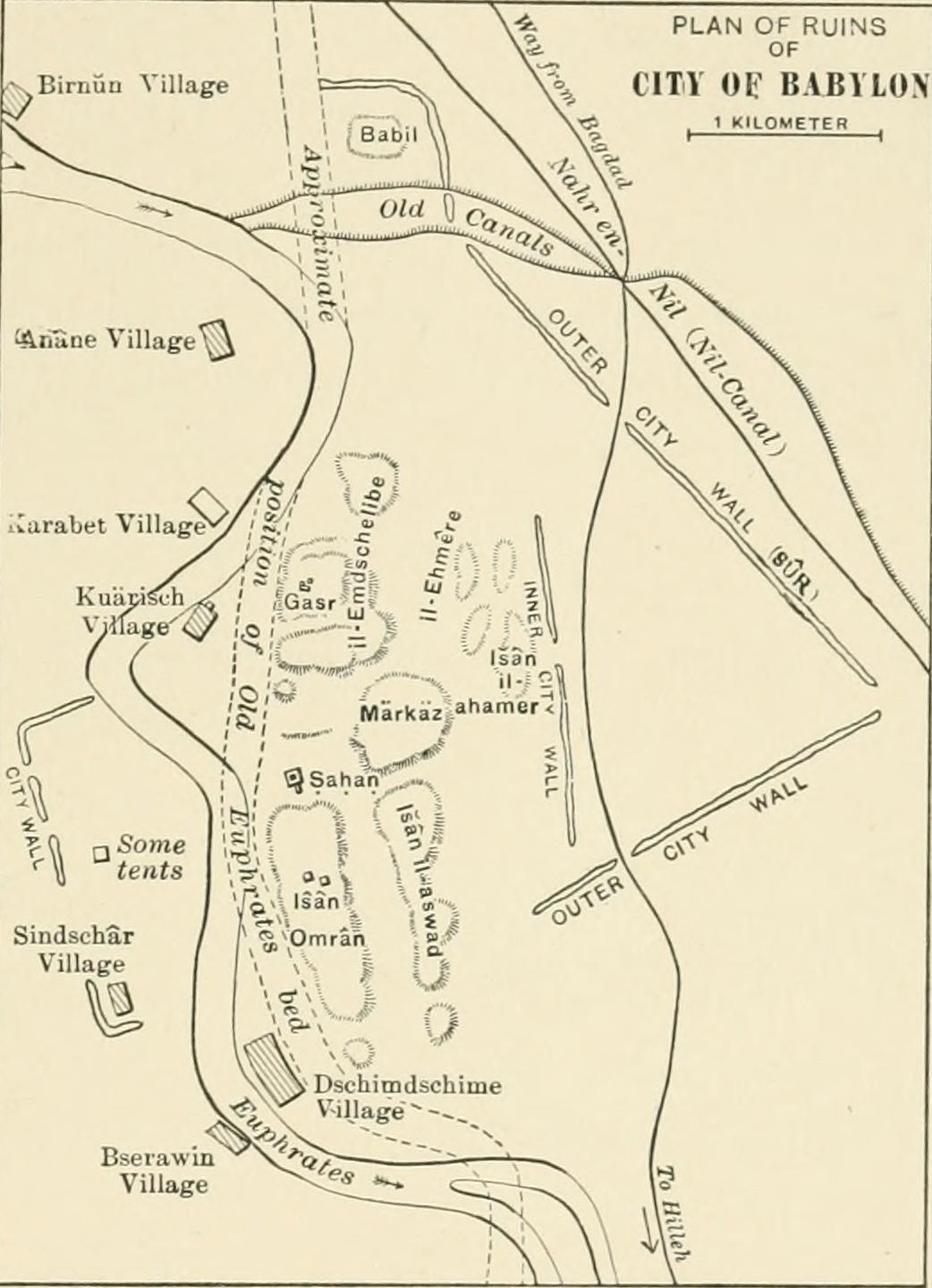
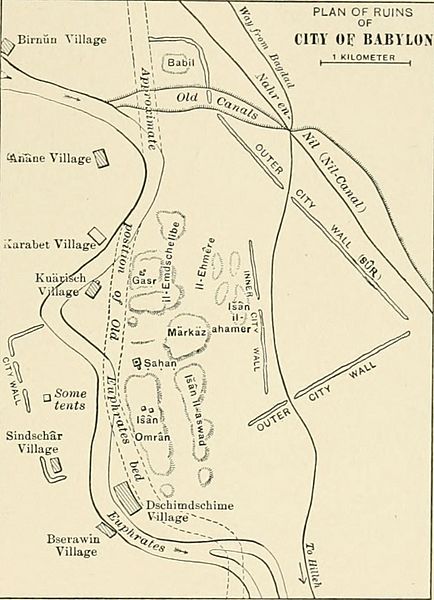
Description: Identifier: historyofallnati02wrig Title: A history of all nations from the earliest times; being a universal historical library Year: 1905 (1900s) Authors: Wright, John Henry, 1852-1908 Subjects: World history Publisher: [Philadelphia, New York : Lea Brothers & company Contributing Library: University of California Libraries Digitizing Sponsor: Internet Archive View Book Page: Book Viewer About This Book: Catalog Entry View All Images: All Images From Book Click here to view book online to see this illustration in context in a browseable online version of this book. Text Appearing Before Image: cjuite anotherscale. By him it was made to assume the character of a small fortifiedstate, rather than that of a city (Fig. 28). Double walls begun byNabopalassar and completed by Nebuchadnezzar—named in the in-scriptions Imgur-Bel (* Bel blesses) and Nimitti-Bel (protectionof Bel) —surrounded the section in which a group of three palacesstood, and walls, forts, towers, and gates protected other portionsof the city as well. The stream was flanked on both sides by NEBUCHADNEZZARS BABYLON. 129 parapet-walls (completed by Nabonidus), through which gatesopened on the water. Nothing is now left of these walls but smallrubbish-mounds, for as they gradually sunk into decay, the trencheswere filled up whence the clay for the bricks had been dug; whileseveral cities were built from the material. Even to this day theextraction of bricks from the ruins for export is a lively industry.The royal city had also its special walls, and of these the eastern PLAN OF RUINSOF CITY Of BABYLON tlLQMETE Text Appearing After Image: Fio. 28. — Plan of the Ruins of Babylon.[From Weisshac/i, die Stadt Buhylim (Leipzig, 1904).] corner is still extant. Herodotus, who tells us that he visited Baby-lon, gives as the circumference of the outmost wall (which alreadyin his day had been in places destroyed by the Persians) 480 stadia,or a little over bo miles, stating that it had 250 towers and 100gates of bronze (cased with bronze). The diagonal formed by theEuphrates — if treated as a straight line, 170 stadia or nearly 20miles in length — divided the square into two triangles, in one ofwhich stood the royal city; in the other, within a sacred precinct of Vol. II.—9 130 ^l*>^^^ AFTER THE FALL OF ASSYRIA. one-quarter of a mile in circumference, a temple of eight towers(stages), surrounded by a spiral ramp, and containing the shrine andimage of Marduk. The triaugles were connected by a wooden bridgeon stone piers. Ctesias, the only extant Greek author besides He-rodotus who saw ancient Babylon, gives the circumf Note About Images Please note that these images are extracted from scanned page images that may have been digitally enhanced for readability - coloration and appearance of these illustrations may not perfectly resemble the original work.
Title: Plan of Ruins of Babylon 1905
Credit: Image from page 148 of "A history of all nations from the earliest times; being a universal historical library" (1905)
Author: Internet Archive Book Images
Permission: Internet Archive Book Images @ Flickr Commons
Usage Terms: No known copyright restrictions
License: No restrictions
License Link: https://www.flickr.com/commons/usage/
Attribution Required?: No
Image usage
The following page links to this image:
