
Image: Plan of Seattle 1855-6

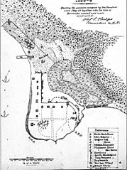
Description: A map of Seattle, drawn at the time of the Battle of Seattle, part of the Puget Sound War. Map shows the sloop USS Decatur and the bark Brontes in Elliott Bay, Henry Yesler's mill, wharf, and a pile of sawdust, indigenous settlements in and around town (depicted with tipi-like symbols). The camp in town is labeled "Tecumseh's Camp", the one in the woods just north of Yesler's Mill is labeled "Curley's Camp" On the slopes above the town there is text saying "Hills and Woods thronged with Indians". A sand spit separates a tide marsh from the tide flats of the bay. The location is roughly where Seattle's Pioneer Square is today. The main north-south street is today's First Avenue, the main west-east street shown is today's Jackson Street. Today's Yesler Way would terminate at the wharf. The marsh and tide flats have been filled and developed since 1855. Caption on image: Plan of Seattle, 1855–6: showing the position occupied by the Decatur's crew, Jany 26, together with the line of barricades erected and roads constructed.
Title: Plan of Seattle 1855-6
Credit: University of Washington Libraries. Special Collections Division. Seattle Photograph Collection. Website: http://content.lib.washington.edu/seattleweb/index.html Image: http://content.lib.washington.edu/u?/seattle,328 Accessed 12 October 2010.
Author: Drawn by Lieutenant Thomas S. Phelps of the Decatur and photographed by an unknown photographer.
Usage Terms: Public domain
License: Public domain
Attribution Required?: No
Image usage
The following page links to this image:
