
Image: Plan of the attack against Fort Louis now Fort George, at Point à Pitre on the island of Guadaloupe - by a squadron of His Majesty's ships of war, detached from Commodore Moore and commanded by Capt. (18164015469)

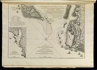
Description: Zoom into https://collections.leventhalmap.org/search/commonwealth:q524n5382 at http://maps.bpl.org. Publisher: Jefferys, Thomas, Sayer, Robert Lieut Col.l Edward Rycaut RM (d. 1763) (surveyor) Date: 1768 Dimensions: 33 x 47 cm. Scale: [ca. 1:6,500] Reference: Phillips. List of maps of America, p. 292 Reference: Phillips, 1196 Identifier:4000137_0110r Call Number: G1105 .J4 1768 Barcode:30000003256624 Norman B. Leventhal Map Center at the BPL
Title: PLAN of the ATTACK against FORT LOUIS now FORT GEORGE, at Point à Pitre on the ISLAND of GUADALOUPE: By a Squadron of his Majesty’s Ships of War, detached from Commodore MOORE, & Commanded by Cap.t W.M HARMAN, on the 14 February 1759
Credit: https://www.flickr.com/photos/normanbleventhalmapcenter/18164015469/
Author: Thomas Jefferys
Permission: At the time of upload, the image license was automatically confirmed using the Flickr API. For more information see Flickr API detail.
Usage Terms: Public domain
License: Public domain
Attribution Required?: No
Image usage
The following page links to this image:

.jpg)