
Image: Polska-ww1-nation

Size of this preview: 474 × 599 pixels. Other resolutions: 190 × 240 pixels | 791 × 1,000 pixels.
Original image (791 × 1,000 pixels, file size: 164 KB, MIME type: image/png)
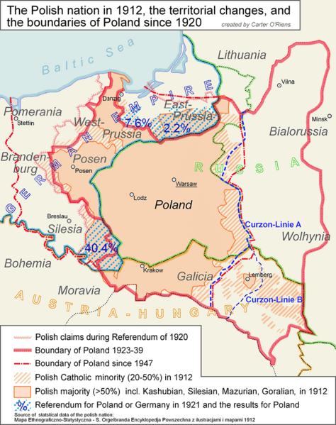
Description: The map shows the area in which Polish people have a majority (aggregated on a NUTS 3 like level) based on a Polish statistical map of 1910. In addition to this it shows the pre-ww1 boundaries, the boundary of the Second Polish Republic, Curzon-Line A and B, the plebicite areas and the current boundary of Poland.
Title: Polska-ww1-nation
Credit: Mapa Ethnograficzno-Statystyczna - S. Orgelbranda Encyklopedja Powszechna z ilustracjami i mapami 1912/Own work by uploader
Author: Exec
Usage Terms: Creative Commons Attribution-Share Alike 3.0
License: CC BY-SA 3.0
License Link: https://creativecommons.org/licenses/by-sa/3.0
Attribution Required?: Yes
Image usage
The following page links to this image:

All content from Kiddle encyclopedia articles (including the article images and facts) can be freely used under Attribution-ShareAlike license, unless stated otherwise.