
Image: Population Density by Pakistani District - 2017 Census

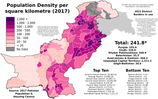
Description: The map above shows the population density (per square kilometre) of each Pakistani district according to the final official results of the 2017 Pakistan Population & Housing Census. The data can be found here for the four provinces and ICT, here for Azad Kashmir, and here for Gilgit-Baltistan. NOTE: Only approximate data (to the nearest ten thousand) is available for seven of Gilgit-Baltistan's districts. The other seven districts of Gilgit-Baltistan are newly created (or experienced border changes) and data for them is not yet available. However, data for the territory as a whole has been released and is incorporated into the national total displayed below. This image file shall be updated with the data for those seven districts when it is released. NOTE: Area data for the three districts of Kohistan: Kolai-Palas, Lower Kohistan, and Upper Kohistan, has not yet been made available by the Pakistan Bureau of Statistics. The total population density of the region, 104.74, has been calculated and incorporated into the provincial and national averages.
Legend 2,000+ 1,000 - 1,500 500 - 1,000 200 - 500 100 - 200 50 - 100 20 - 50 < 20
Author: Abbasi786786
Usage Terms: Creative Commons Attribution-Share Alike 3.0
License: CC-BY-SA-3.0
License Link: http://creativecommons.org/licenses/by-sa/3.0/
Attribution Required?: Yes
Image usage
The following page links to this image:
