
Image: Population density of Ireland map2002

Size of this PNG preview of this SVG file: 480 × 600 pixels. Other resolution: 192 × 240 pixels.
Original image (SVG file, nominally 800 × 1,000 pixels, file size: 621 KB)
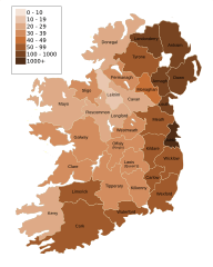
Description: Map of Ireland's population density (people per km2). Based upon Republic of Ireland - 2002 Census results.
Title: Population density of Ireland map2002
Credit: Ireland_complete.svg
Author: Ireland_complete.svg: Future Perfect at Sunrise derivative work: The Illusional Ministry (talk)
Usage Terms: Public domain
License: Public domain
Attribution Required?: No
Image usage
There are no pages that link to this image.

All content from Kiddle encyclopedia articles (including the article images and facts) can be freely used under Attribution-ShareAlike license, unless stated otherwise.