
Image: Port-of-Hakodate-Map-1863

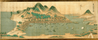
Description: Port of Hakodate Map (奥州箱館之図). It depicts the port of Hakodate around 1863, shortly after the opening of the port. Hakodateyama is located in front, and Hakodate Port spreads out to the right. There is Benten Daiba at the mouth of the bay, and Goryokaku is drawn at the bottom left of the screen, which is a little away from the town that spreads out at the foot of the mountain, but it is a pure Japanese-style castle. The building in the middle of the forest is the Hakodate government office, near the current Motomachi Park. Inside the harbor, a steamship with the flags of Russia, the United States, the United Kingdom, and the Netherlands is drawn along with many Japanese ships. Even around the first and second years of the Meiji era, when the Battle of Hakodate began, it would have been such a quiet situation when there was no battle.
Title: Port-of-Hakodate-Map-1863
Credit: Hakodate Hekketsukai / Secretariat https://www.hekketsu.org/archives.html , Hakodate City Museum collection
Author: Unknown
Usage Terms: Public domain
License: Public domain
Attribution Required?: No
Image usage
The following page links to this image:
