
Image: Prairie D'Ane Battlefield Arkansas

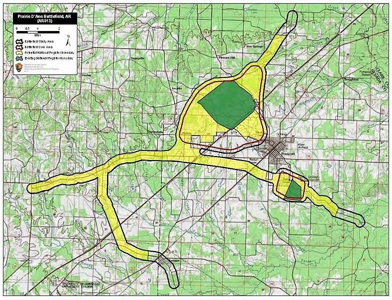
Description: Map of battlefield core and study areas. The ABPP revised the Study Area to reflect more accurately troop movements, lines of battle, locations of Confederate earthworks, approach and withdrawal routes, and the landscape of the Prairie D'Ane. Routes added include Steele's approach from the north from his encampment on the Cornelius Farm; Price's approach from the west from Washington (he also withdrew along this route); Steele's withdrawal to the east toward Camden; and Brigadier General John Marmaduke's withdrawal route to the south towards Prairie De Rohan. All routes saw skirmishing among various elements of both forces. The larger Core Area was shifted to the west along the historic road alignment. It was also widened to encompass lines of battle over several days as well as the Confederate earthworks near present day Midway. The smaller Core Area represents “The Battle of Moscow," a rearguard engagement around and in the town of Moscow.
Title: Prairie D'Ane Battlefield Arkansas
Credit: National Park Service
Author: American Battlefield Protection Program
Usage Terms: Public domain
License: Public domain
Attribution Required?: No
Image usage
The following page links to this image:
