
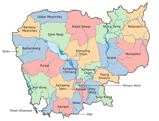
Image: Provincial Boundaries in Cambodia

Size of this PNG preview of this SVG file: 691 × 524 pixels. Other resolution: 317 × 240 pixels.
Original image (SVG file, nominally 691 × 524 pixels, file size: 9.9 MB)
Description: Up-to-date map of provincial boundaries in Cambodia, with accurate shapes.
Title: Provincial Boundaries in Cambodia
Credit: Map created by myself using QGIS
Author: NIRVn
Usage Terms: Creative Commons Attribution-Share Alike 3.0
License: CC BY-SA 3.0
License Link: https://creativecommons.org/licenses/by-sa/3.0
Attribution Required?: Yes
Image usage
The following page links to this image:

All content from Kiddle encyclopedia articles (including the article images and facts) can be freely used under Attribution-ShareAlike license, unless stated otherwise.