
Image: Pyrenees-Atlantiques-fr-cropped

Size of this preview: 800 × 360 pixels. Other resolutions: 320 × 144 pixels | 1,738 × 782 pixels.
Original image (1,738 × 782 pixels, file size: 726 KB, MIME type: image/png)
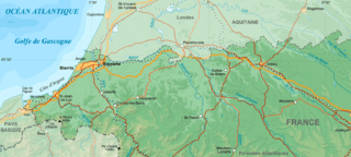
Description: Map of French department of Pyrenees-Atlantiques cropped to show only the area between Bayonne and Orthez.
Title: Pyrenees-Atlantiques-fr-cropped
Credit: Wikipedia Commons map File:Pyrenees-Atlantiques topographic map-fr.jpg. Cropped to a smaller area to show the 1814 military campaign of Bayonne and Orthez.
Author: Eric Gaba (fr:User:sting)
Usage Terms: Creative Commons Attribution-Share Alike 4.0
License: CC BY-SA 4.0
License Link: https://creativecommons.org/licenses/by-sa/4.0
Attribution Required?: Yes
Image usage
The following 2 pages link to this image:

All content from Kiddle encyclopedia articles (including the article images and facts) can be freely used under Attribution-ShareAlike license, unless stated otherwise.