
Image: Rail transport infrastructure map - Northern Ireland

Size of this PNG preview of this SVG file: 715 × 600 pixels. Other resolution: 286 × 240 pixels.
Original image (SVG file, nominally 1,172 × 983 pixels, file size: 2.55 MB)
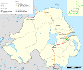
Description: Geographically correct rail transport infrastructure map of Northern Ireland, as of 2024. NB : Maximum speed informations approximate in Northern Ireland, due to a lack of precise sources.
Title: Rail transport infrastructure map - Northern Ireland
Credit: Own work
Author: Shapes of borders, coasts and lakes use data from EGM 2020 database, published by Institut géographique national under Licence ouverte / Open license from Etalab.
Usage Terms: Creative Commons Attribution-Share Alike 4.0
License: CC BY-SA 4.0
License Link: https://creativecommons.org/licenses/by-sa/4.0
Attribution Required?: Yes
Image usage
The following page links to this image:

All content from Kiddle encyclopedia articles (including the article images and facts) can be freely used under Attribution-ShareAlike license, unless stated otherwise.