
Image: Rame peninsula - geograph.org.uk - 1337292
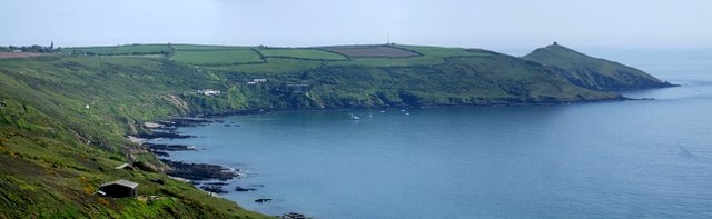
Description: Rame peninsula. This panoramic shot of the Rame peninsula takes in its sweep from Rame Church (far left at SX426491) to the chapel on Rame Head (the little square, far right at SX418483 ). Between these but nearer the latter can just be made out the mast of the Coast Guard station (at SX420487). Nearer sea-level the buildings clustered towards the left are at Polhawn, with Polhawn Fort, dating from Napoleonic times, the rightmost of these. A clutch of boats can be seen dotting the sea near the coves (Polhawn, Crane and Long) of this coast. The photo was taken from the coast road - also known as the Military Road - that runs along the top of the cliffs above Whitsand Bay. The actual spot it was taken from is directly above 529712 which lie on the sands due south west, and about 350' (100m) below.
Title: Rame peninsula - geograph.org.uk - 1337292
Credit: From geograph.org.uk
Author: Rob Farrow
Usage Terms: Creative Commons Attribution-Share Alike 2.0
License: CC BY-SA 2.0
License Link: http://creativecommons.org/licenses/by-sa/2.0
Attribution Required?: Yes
Image usage
The following page links to this image:
