
Image: Ricketts Glen Lakes 1939 labels

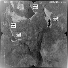
Description: Aerial photo from 1939 of the lakes in w:Ricketts Glen State Park in Sullivan and Luzerne Counties, Pennsylvania in the United States. Pennsylvania Route 487 is the highway running vertically along the left side of the image. North is up. Lakes are Lake Jean (top left), Mud Pond (top center, now part of a larger Lake Jean), Lake Leigh (top right, drained in 1956) and Lake Rose (middle left, drained in 1969). Lake Rose drains into Ganoga Glen and Lake Leigh drains into Glen Leigh, these valleys meet at Waters Meet and Ricketts Glen is south and downstream of that).
Title: Ricketts Glen Lakes 1939 labels
Credit: File is here at the Penn Pilot website, "a project sponsored by the Pennsylvania Geological Survey, is an online library of digital historical aerial photography for the Commonwealth of Pennsylvania." Original file name was "lycoming_050659_aqe_4w_57.jpg"
Author: According to this, "The photos were produced by the United States Department of Agriculture, Agricultural Adjustment Administration (now known as the Farm Service Agency)." Labels added by Ruhrfisch (talk)
Permission: This image or file is a work of a United States Department of Agriculture employee, taken or made as part of that person's official duties. As a work of the U.S. federal government, the image is in the public domain.
Usage Terms: Public domain
License: Public domain
Attribution Required?: No
Image usage
The following page links to this image:
