
Image: Rottnest aerial photo 2

Size of this preview: 800 × 600 pixels. Other resolutions: 320 × 240 pixels | 2,560 × 1,920 pixels.
Original image (2,560 × 1,920 pixels, file size: 5.29 MB, MIME type: image/jpeg)
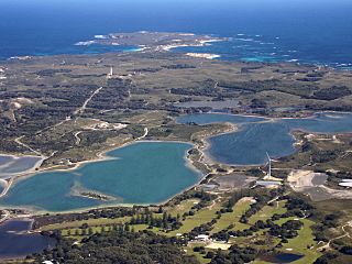
Description: Aerial photograph of central Rottnest Island, photographed from above the Thomson Bay settlement, looking west towards Cape Vlamingh. Visible in the foreground are the golf course, wind turbine, Mt Herschell and some salt lakes.
Title: Rottnest aerial photo 2
Credit: Own work
Author: Mark
Usage Terms: GNU Free Documentation License
License: GFDL
License Link: http://www.gnu.org/copyleft/fdl.html
Attribution Required?: Yes
Image usage
The following 2 pages link to this image:

All content from Kiddle encyclopedia articles (including the article images and facts) can be freely used under Attribution-ShareAlike license, unless stated otherwise.