
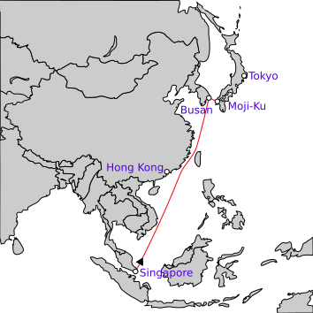
Image: Route of operation Kita

Size of this PNG preview of this SVG file: 354 × 354 pixels. Other resolution: 240 × 240 pixels.
Original image (SVG file, nominally 354 × 354 pixels, file size: 120 KB)
Description: Map of the route taken by Japanese forces during Operation Kita.
Title: Route of operation Kita
Credit: Own work using: File:Empire_of_Japan_(1868-1945).svg File:Operation_Kita.jpg (Army Map Service)
Author: User:Derfel73
Usage Terms: Creative Commons Attribution 3.0
License: CC BY 3.0
License Link: https://creativecommons.org/licenses/by/3.0
Attribution Required?: Yes
Image usage
The following page links to this image:

All content from Kiddle encyclopedia articles (including the article images and facts) can be freely used under Attribution-ShareAlike license, unless stated otherwise.