
Image: Royal Naval Dockyard Bermuda circa 1899 Ordnance Survey map by Lieutenant Arthur Johnson Savage, RE
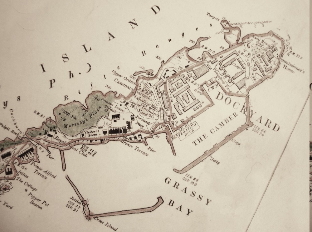
Description: Ordnance Survey map of the Royal Naval Dockyard on Ireland Island North, Bermuda, from an Ordnance Survey map of Bermuda published in 1901 based on surveys carried out by Lieutenant Arthur Johnson Savage, Royal Engineers, between approximately 1896 and 1899. The map shows the original Royal Naval Dockyard at the North (right), with the original location in the camber of the Floating Dry Dock Bermuda, protected by a breakwater or arm, and the new South Yard under construction with its own breakwater. On completion in 1903, the new Admiralty Floating Dock 1 (AFD1) would be located in the South Camber, protected by the South Arm. The new South Yard was constructed outside the area protected by fortifications. The Casemates Naval Barracks (used at various times by the Army Ordnance Corps, though the Ordnance Depot would finally be located in The Keep of the fortress at the Northernmost point) stood on a highpoint behind the southern casemates of the old fortified dockyard that was to become the North Yard with the completion of the South Yard. The Cut Bridge at the South of Ireland Island North crosses an artificial channel cut through Ireland Island. Various satellite facilities, such as the Royal Naval Hospital, and married accommodations for the dockyard were located on Ireland Island South and elsewhere in Bermuda.[1][2][3] References ↑ Jones, Simon (2015-10-23). "Book details history of Savage family". The Royal Gazette, City of Hamilton, Pembroke, Bermuda. ↑ Harris, Dr. Edward Cecil (2014-03-22). "Dr. Savage’s St George’s walkabout". The Royal Gazette, City of Hamilton, Pembroke, Bermuda. ↑ Harris, Dr. Edward Cecil (2014-07-12). "A palette off the old block". The Royal Gazette, City of Hamilton, Pembroke, Bermuda.
Title: Royal Naval Dockyard Bermuda circa 1899 Ordnance Survey map by Lieutenant Arthur Johnson Savage, RE
Credit: Photographed from hand-coloured, original Ordnance Survey full-size print (approximately 8 feet wide) of entire survey map of Bermuda, published in 1901 based on surveys carried out by Lieutenant Arthur Johnson Savage, Royal Engineers, between approximately 1896 and 1899.
Author: Lieutenant Arthur Johnson Savage, Royal Engineers
Usage Terms: Public domain
License: Public domain
Attribution Required?: No
Image usage
The following 2 pages link to this image:
