
Image: SaintPierre1772

Size of this preview: 800 × 362 pixels. Other resolutions: 320 × 145 pixels | 1,105 × 500 pixels.
Original image (1,105 × 500 pixels, file size: 231 KB, MIME type: image/png)
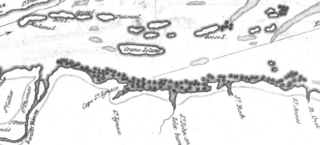
Description: This is a detail from the source map, which is titled as follows: River St. Lawrence from Montréal to the Island of St. Barnaby... and the Island of Jeremy. This detail shows a portion of the Saint Lawrence River east of Quebec City, showing locations of note in the March 1776 Battle of Saint-Pierre: Crane Island (Île-aux-Grues), St. Anne's (St.-Anne-de-la-Pocatiere), St. Thomas, and St. Peter (Saint-Pierre).
Title: SaintPierre1772
Credit: This image is available from Bibliothèque et Archives nationales du Québec under the reference number 0002663585
Author: Thomas Kitchin
Usage Terms: Public domain
License: Public domain
Attribution Required?: No
Image usage
The following page links to this image:

All content from Kiddle encyclopedia articles (including the article images and facts) can be freely used under Attribution-ShareAlike license, unless stated otherwise.