
Image: Salem Beverly Waterway Canal - USGS map (1 July 1985)

Size of this preview: 750 × 600 pixels. Other resolutions: 300 × 240 pixels | 1,000 × 800 pixels.
Original image (1,000 × 800 pixels, file size: 294 KB, MIME type: image/jpeg)
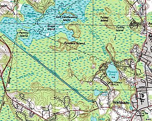
Description: Topographic map of (nearly all) the Salem Beverly Waterway Canal, located in Topsfield and Wenham, Massachusetts, USA.
Title: Salem Beverly Waterway Canal - USGS map (1 July 1985)
Credit: United States Geological Survey map, published July 1, 1985.
Author: United States Geological Survey (USGS).
Permission: Original work of the US Federal Government - public domain
Usage Terms: Public domain
License: Public domain
Attribution Required?: No
Image usage
The following page links to this image:

All content from Kiddle encyclopedia articles (including the article images and facts) can be freely used under Attribution-ShareAlike license, unless stated otherwise.
.jpg)